𝗝𝗢𝗜𝗡 𝗢𝗨𝗥 𝗪𝗛𝗔𝗧𝗦𝗔𝗣𝗣 𝗖𝗛𝗔𝗡𝗡𝗘𝗟! 𝗖𝗟𝗜𝗖𝗞 𝗢𝗡 𝗧𝗛𝗘 𝗟𝗜𝗡𝗞: https://whatsapp.com/channel/0029VaN7nmQGOj9na4QhBa12

Tropical Weather Outlook
NWS National Hurricane Center Miami FL
800 PM EDT Mon Jun 15 2026
For the North Atlantic… Caribbean Sea and the Gulf of America:

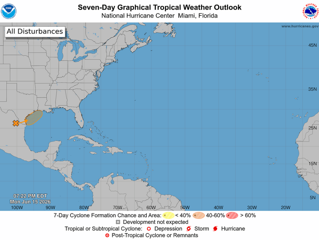
Northwestern Gulf of America:
A trough of low pressure located over northeastern Mexico continues to produce a large area of disorganized showers and thunderstorms. Development is not expected during the next day or so while the trough remains inland.
However, the system could re-emerge over the northwestern Gulf of America late Tuesday or Wednesday, and environmental conditions there are marginally conducive for the formation of a short-lived tropical storm on Wednesday into Thursday.

Regardless of tropical cyclone formation, interests across southern and eastern Texas and portions of Louisiana and Mississippi should prepare for periods of intense rainfall over the next several days which could produce widespread, life-threatening flash, urban, and river flooding.
Gusty winds and coastal flooding are also possible along portions of the northwestern Gulf Coast, and Tropical Storm
Watches or Warnings could be required on Tuesday.

Additional information on this system can be found in products issued by your local National Weather Service Forecast Office or NHC Key Messages.
- Formation chance through 48 hours…medium…50 percent.
- Formation chance through 7 days…medium…50 percent.


Leave a comment