
𝗝𝗢𝗜𝗡 𝗢𝗨𝗥 𝗪𝗛𝗔𝗧𝗦𝗔𝗣𝗣 𝗖𝗛𝗔𝗡𝗡𝗘𝗟! 𝗖𝗟𝗜𝗖𝗞 𝗢𝗡 𝗧𝗛𝗘 𝗟𝗜𝗡𝗞: https://whatsapp.com/channel/0029VaN7nmQGOj9na4QhBa12

WOCA31 TAPA
Tropical Cyclone Information Statement
Antigua and Barbuda meteorological service
3:00 pm, ETC., Thursday, August 27, 2026
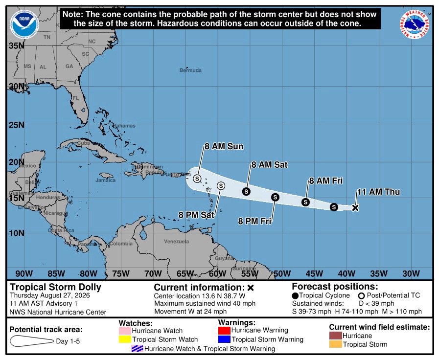
The wind risk to the islands is very low; no action required. The Antigua and Barbuda Meteorological Service is following the progress of Tropical storm dolly, which was previously Tropical Disturbance AL96, located over the central tropical North Atlantic Ocean.

The system is likely to dissipate before reaching the islands. The best available forecast has Dolly dissipating in 48 hours, about 300 miles east of the islands on Saturday. In the reasonable worst-case scenario, it could reach the islands as a minimal tropical storm.
At this time, the risk of wind and rainfall impacts from Dolly is very low; no action is required; the risk of wave impacts is moderate; be aware. Residents of the Leeward Islands and the British Virgin Islands should monitor this system.

To be safe, everyone is reminded to remain prepared for the remainder of the hurricane season.
At 11 am ECT, or 1500 UTC, Tropical Storm Dolly was centered about 1550 miles east-southeast of Antigua and Barbuda and the rest of the leeward islands moving west at around 24 mph.

The maximum sustained winds are near 40 mph. On the forecast track, this system could be near the Leeward Islands this Saturday/Sunday.
Little change in strength is forecast during the next 48 hours, and Dolly is forecast to degenerate into a tropical wave before it reaches the Leeward Islands.

Please note that there are no tropical cyclone alerts, watches, or warnings in effect for the area at this time, but an alert may be required later today. The next update will be around 2 pm tomorrow, or sooner if required.
Forecaster Dale Destin


 safety steps
Leave a comment