𝗝𝗢𝗜𝗡 𝗢𝗨𝗥 𝗪𝗛𝗔𝗧𝗦𝗔𝗣𝗣 𝗖𝗛𝗔𝗡𝗡𝗘𝗟! 𝗖𝗟𝗜𝗖𝗞 𝗢𝗡 𝗧𝗛𝗘 𝗟𝗜𝗡𝗞: https://whatsapp.com/channel/0029VaN7nmQGOj9na4QhBa12

St. James, Barbados, – As the Caribbean is preparing for yet another hurricane season, a new regional training initiative is supporting disaster management professionals improve how they prepare for and respond to intensified climate-related threats.
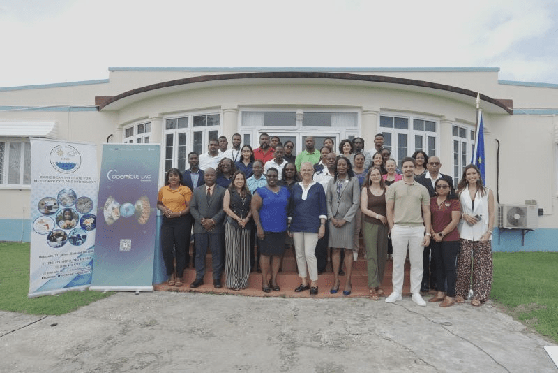
From 19 to 23 May, 28 participants from 13 Caribbean countries have gathered in Barbados for a five-day course focused on harnessing satellite data to strengthen emergency planning and resilience.

Hosted at the Caribbean Institute for Meteorology and Hydrology (CIMH) in St. James from 19 to 23 May, this training introduces participants to accessible, free European Union Copernicus tools for analysing Earth Observation (EO) data and satellite imagery and turning this information into practical insights for real-world decision-making in the event of a disaster.
The course, titled Earth Observation: Principles and Tools, introduces the participants to this free and open-source software to explore how Copernicus products can support their daily work. Copernicus is the EU’s Earth observation programme, offering services based on satellite and ground-based data that are freely available to all.

Participants from Barbados and across the region – including Antigua and Barbuda, Bahamas, Belize, Cuba, Dominica, Dominican Republic, Grenada, Guyana, St. Kitts and Nevis, St. Lucia, St. Vincent and the Grenadines and Trinidad and Tobago – are gaining hands-on skills, as these tools that can help civil protection agencies, meteorological services, and planning offices assess risk exposure, monitor environmental changes, and respond more effectively to emergencies.
The course is led by Dr Caterina Peris Ferrús and Dr Akram Elghouat, experts in EO services development, who guide participants through practical exercises in data analysis and impact assessment.

Sessions are designed to build confidence in using EO tools for disaster preparedness and risk reduction planning. It responds to a growing need for enhanced disaster risk management capacity across a region that is among the most vulnerable globally to extreme weather and other hazards.
It is organised by the European Union, and more specifically, the EU’s CopernicusLAC Panama Centre, on behalf of the European Space Agency (ESA) in close partnership with the European Union Delegation to Barbados, the Eastern Caribbean States, the OECS and CARICOM/CARIFORUM, the Caribbean Disaster Emergency Management Agency (CDEMA), the Caribbean Institute for Meteorology and Hydrology and the Caribbean-EU Cooperation Facility project.

It is part of a broader effort under the European Union Global Gateway strategy and the EU-LAC Digital Alliance to support technical knowledge-sharing and digital cooperation between Europe and the Caribbean The activity is part of broader, cross-cutting and continuous cooperation on disaster risk reduction between the European Union and Latin America and the Caribbean – as also reflected in the Memorandum of Understanding on disaster risk management between the two regions.

In her speech at the inaugural event of the training, H.E. Ms Malgorzata Wasilewska, Ambassador of the European Union to Barbados, highlighted:
“This training takes place during the European Union’s Europe Month. In the Caribbean, it’s a chance to celebrate the strong and evolving partnership between the EU and the region, particularly in areas like strengthening resilience, where cooperation continues to deepen.
By providing public institutions with access to reliable data and the skills to use it effectively, this initiative is contributing to a stronger, more prepared Caribbean—better equipped to anticipate risk and protect communities”

In her welcome address, Ms Claudia Herrera, Stakeholder Engagement Officer at the CopernicusLAC Panama Centre, noted: “At the CopernicusLAC Centre in Panama, we are firmly committed to supporting Caribbean nations in building stronger resilience to disasters. There is clear evidence that the use of Earth observation data not only increases response efforts in the face of extreme events but also plays a crucial role in strengthening disaster preparedness policies and systems. Training programmes such as the one we are launching today provide essential tools to the dedicated professionals who are at the forefront of building disaster resilience across the Caribbean.”
Ms Kathy-Anne Caesar, Chief Meteorologist, on behalf of Dr. David Farrell, Principal of CIMH, emphasized the importance of integrating Earth observation tools into regional disaster planning, encouraging to learn and share beyond this workshop so that we can grow together in the challenges of disasters.
Ms. Elizabeth Riley, Executive Director at CDEMA, understored the benefit of Earth Observation Data saying: “The value of Earth Observation data is not theoretical—it has already proven impactful in operational settings. In 2024 alone, Copernicus services were leveraged by the Regional Response Mechanism coordinated by CDEMA to support decision-making and response during Hurricane Beryl and the unprecedented wildfires in Belize. These examples demonstrate the power of geospatial intelligence in enhancing situational awareness and coordination during crises.”


Leave a comment