
𝗝𝗢𝗜𝗡 𝗢𝗨𝗥 𝗪𝗛𝗔𝗧𝗦𝗔𝗣𝗣 𝗖𝗛𝗔𝗡𝗡𝗘𝗟! 𝗖𝗟𝗜𝗖𝗞 𝗢𝗡 𝗧𝗛𝗘 𝗟𝗜𝗡𝗞: https://whatsapp.com/channel/0029VaN7nmQGOj9na4QhBa12

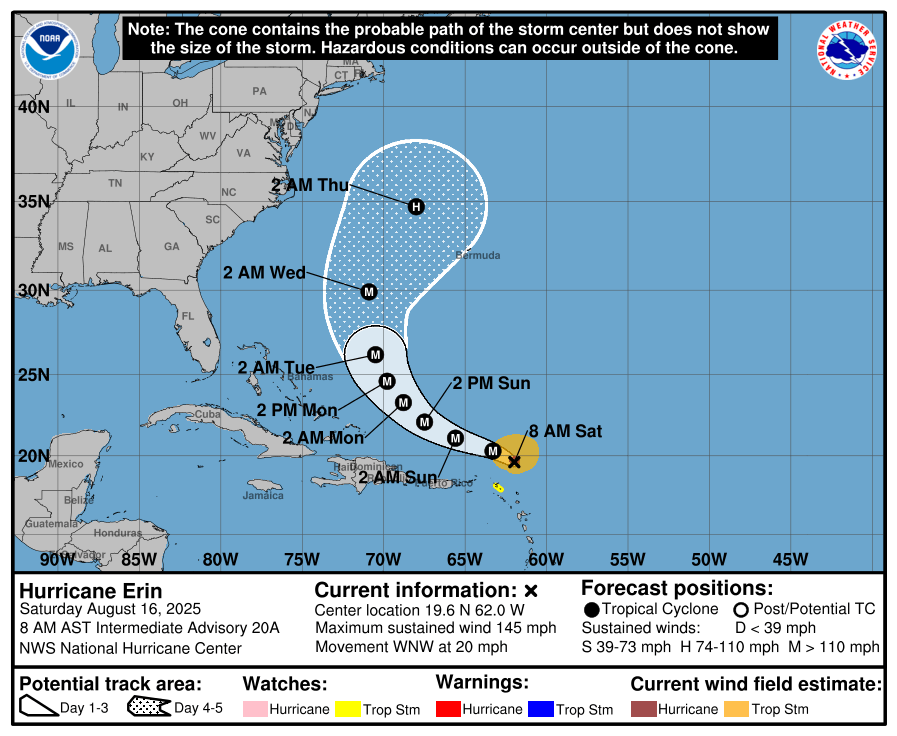
At 800 AM AST (1200 UTC), the center of Hurricane Erin was located near latitude 19.6 North, longitude 62.0 West. While the eye has wobbled westward during the past few hours, Erin is moving generally toward the west-northwest near 20 mph (31 km/h).

This motion is expected to continue through the weekend with a gradual decrease in forward speed. A turn toward the north is expected to occur early next week.
On the forecast track, the center of Erin is expected to move just north of the northern Leeward Islands, the Virgin Islands, and Puerto Rico over the weekend.

Reports from NOAA and Air Force Reserve Hurricane Hunter aircraft indicate that maximum sustained winds have increased to near 145 mph (230 km/h) with higher gusts.
Erin is a category 4 hurricane on the Saffir-Simpson Hurricane Wind Scale. Continued rapid strengthening is expected today, followed by fluctuations in intensity through the weekend.
Hurricane-force winds extend outward up to 30 miles (45 km) from the center and tropical-storm-force winds extend outward up to 125 miles (205 km) mainly to the north of the center.
The latest minimum central pressure estimated from Air Force
Reserve Hurricane Hunter aircraft data is 935 mb (27.61 inches).


Leave a comment