𝗝𝗢𝗜𝗡 𝗢𝗨𝗥 𝗪𝗛𝗔𝗧𝗦𝗔𝗣𝗣 𝗖𝗛𝗔𝗡𝗡𝗘𝗟! 𝗖𝗟𝗜𝗖𝗞 𝗢𝗡 𝗧𝗛𝗘 𝗟𝗜𝗡𝗞: https://whatsapp.com/channel/0029VaN7nmQGOj9na4QhBa12

WHCA31 TAPA
TROPICAL CYCLONE INFORMATION STATEMENT
ANTIGUA AND BARBUDA METEOROLOGICAL SERVICE
5:45 PM ECT WEDNESDAY, AUGUST 13, 2025

The Antigua and Barbuda Meteorological Service continues to monitor the progress of strengthening tropical storm Erin.
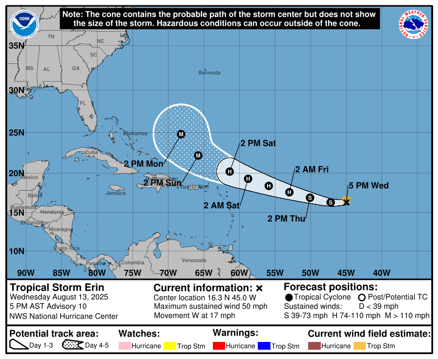
The system is forecast to become a hurricane by Friday and possibly pass dangerously close to Antigua and Barbuda and the rest of the northeast Caribbean.

The best forecast remains for the centre of Erin to pass north of all the islands, with a low chance of sustained storm-force winds. However, further shifts to the south or persistent westward motion could bring the core of the system uncomfortably close to the islands late Friday night or Saturday.

Notwithstanding, it is still too early to know exactly what impacts Erin might bring to the islands. However, the risk from swells will rise; hence, those near coastal areas should be aware. Other hazards could come into play in the next 24 hours.
Interests in the Leeward islands and the British Virgin Islands should monitor the progress of this cyclone and, to be safe, be prepared for the rest of the hurricane season.

At 5 pm ECT or 2100 UTC, Tropical Storm Erin was centred about 1105 miles east of Antigua and Barbuda and the Leeward Islands and moving west at about 17 mph.
Maximum sustained winds are near 50 mph with higher gusts. Gradual strengthening is forecast during the next couple of days. Erin is expected to become a hurricane by Friday.

The chance of storm-force winds reaching the area remains low at a maximum of around 35 percent for Anguilla and lower for the other islands, with Antigua at around 10 percent.
Please note that there are no tropical cyclone alerts, watches or warnings in effect for the area, but this could change by tomorrow, when a tropical storm watch may be required.
The next update will be around 5 pm tomorrow, or sooner if required.
Forecaster Dale Destin


Leave a comment