
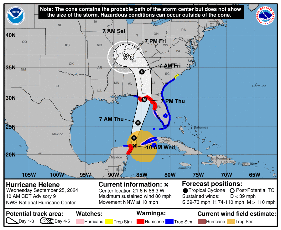
At 1000 AM CDT (1500 UTC), the center of Hurricane Helene was located near latitude 21.6 North, longitude 86.3 West. Helene is moving toward the north-northwest near 10 mph (17 km/h).

A turn toward the north and north-northeast with an increase in forward speed is expected later today through Thursday, bringing the center of Helene across the eastern Gulf of Mexico and to the Florida Big Bend coast by Thursday evening.
After landfall, Helene is expected to slow down and turn toward the northwest over the southeastern United States Friday and Saturday.

Data from NOAA and Air Force Reserve Hurricane Hunter aircraft indicate that maximum sustained winds have increased to near 80 mph (130 km/h) with higher gusts.
Additional strengthening is forecast, and Helene is expected to be a major hurricane when it reaches the Florida Big Bend coast Thursday evening.

Weakening is expected after landfall, but Helene’s fast forward speed will allow strong, damaging winds, especially in gusts, to penetrate well inland across the southeastern United States, including over the higher terrain of the southern Appalachians.
Hurricane-force winds extend outward up to 25 miles (35 km) from the center and tropical-storm-force winds extend outward up to 275 miles (445 km). The minimum central pressure based on dropsonde is 979 mb (28.91 inches).


Leave a comment