WHCA31 TAPA
TROPICAL CYCLONE INFORMATION STATEMENT
ANTIGUA AND BARBUDA METEOROLOGICAL SERVICE
4:10 PM ECT FRIDAY AUGUST 09 2024
…TROPICAL CYCLONE COULD AFFECT THE AREA…
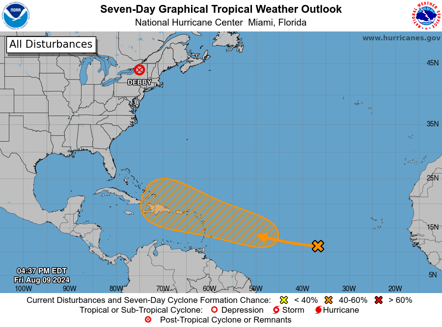
The Antigua and Barbuda Meteorological Service continues to monitor the progress of an active tropical wave, over the central tropical north Atlantic.

The system could develop further and become a concern for the Leeward Islands and the British Virgin Islands next week Tuesday.
The tropical wave could become disturbance al98 in days, and perhaps go on to become a tropical depression or tropical storm before reaching the Caribbean.

At this time, the system poses little to no threat to the Leeward Islands and the British Virgin Islands. The risk of wind, rainfall or seas is very low, so no action is required at this time other than monitoring.
At 2 pm ECT or 1800 UTC, the tropical wave of interest was located about 1706 miles east-southeast of the Leeward Islands moving west at around 15 mph.

Maximum sustained winds are less than 25 mph with higher gusts. Strengthening is forecast and a tropical depression or tropical storm could form in seven days.
Formation could take place near the northeast Caribbean. There is a near-zero percent chance of formation in 48 hours and a 60 percent chance of formation in seven days.
No particular hazard is being forecast at this time as the system is still very far away with lots of room for a number of scenarios to play out. Also, the uncertainties are quite high for what will happen.
Please note that no alerts, watches or warnings are in effect for the area; however, this could change in 48 hours.

Residents should continue to monitor this system closely and ensure their hurricane season plans are prepared. The next update will be around 2 pm tomorrow, or sooner if required.
Forecaster Dale Destin


Leave a comment