WHCA31 TAPA
TROPICAL CYCLONE INFORMATION STATEMENT
ANTIGUA AND BARBUDA METEOROLOGICAL SERVICE
9:00 AM ECT THURSDAY AUGUST 01 2024
…TROPICAL DISTURBANCE IS EXITING THE AREA…
The Antigua and Barbuda Meteorological Service continues to follow the progress of a tropical disturbance. The system is passing over the northern Caribbean, west of the Leeward Islands and the British Virgin Islands as an active tropical wave.

It will exit the area later today. The disturbance, which could become al97, is not likely to become a tropical cyclone (tropical depression, tropical storm or hurricane) before being well away to the west of the northeast caribbean.
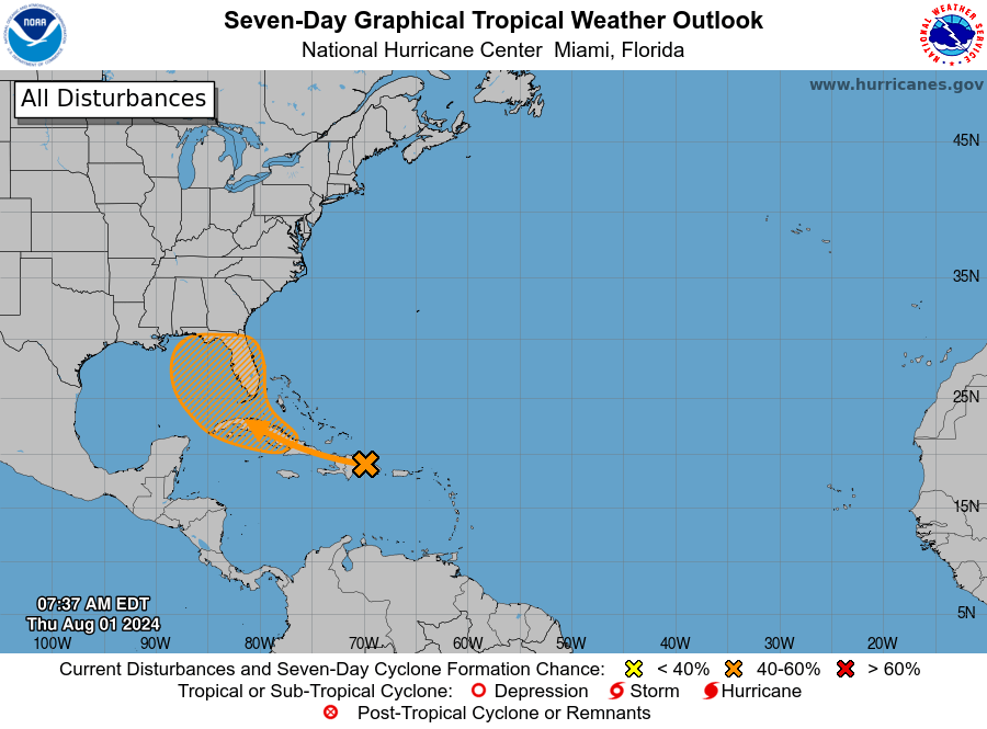
Hence, the system poses no threat to the Leeward Islands and the British Virgin Islands. At 8 am ECT or 1200 UTC, the tropical disturbance was centred over the Dominican Republic moving west-northwest at around 15 mph.

Maximum sustained winds are less than 25 mph with higher gusts. There is a 20 percent chance of formation in 48 hours and a 60 percent chance of formation in seven days.
Notwithstanding the system exiting the area, the instability associated with it is likely to cause more showers and possibly thunderstorms. Thus, residents should remain alert to lightning.
Yesterday, five people were struck by lightning in Sint Maarten. Seek shelter indoors immediately, if you hear thunder or see lightning.

Rainfall total of up to 100 mm or 4 inches has already occurred in the last 36 hours across small parts of the northeast Caribbean and a further 12 to 25 mm or 0.5 to 1 inch is possible over the next 24 hours.
Please note that no alerts, watches or warnings are in effect for the area and none is required.

Residents should continue to monitor the disturbance and ensure their hurricane season plans are in place.
This is the last information statement from the meteorological service on this system.
Forecaster Dale Destin


Leave a comment