Tropical Weather Outlook
NWS National Hurricane Center Miami FL
200 PM EDT Wed Jun 12 2024
For the North Atlantic…Caribbean Sea and the Gulf of Mexico:

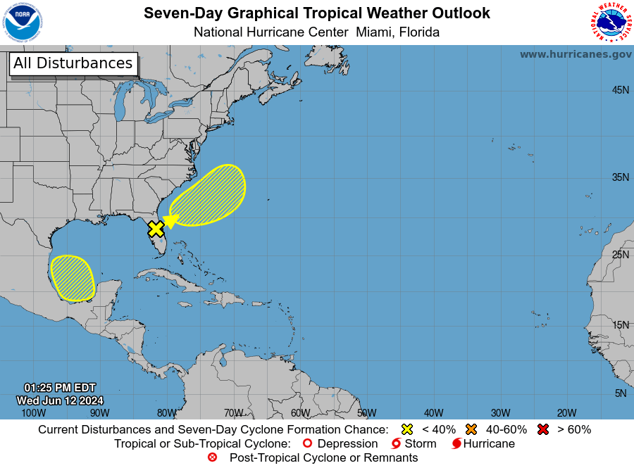
Florida Peninsula and Offshore Southeast U.S. (AL90): An elongated area of low pressure over the Florida peninsula
continues to produce a large area of disorganized showers and
thunderstorms.
Although upper-level winds are expected to be only marginally conducive, some slow development is possible while the
system moves northeastward offshore of the U.S. Southeast coast tonight through late week.

Regardless of development, heavy rainfall is forecast to continue across portions of the Florida peninsula during the next few days.
- Formation chance through 48 hours…low…10 percent.
- Formation chance through 7 days…low…20 percent.

Southwestern Gulf of Mexico:
A broad area of low pressure could form over the weekend across the southwestern Gulf of Mexico.
Environmental conditions appear conducive for some slow development early next week while the system moves slowly westward or west-northwestward.

- Formation chance through 48 hours…low…near 0 percent.
- Formation chance through 7 days…low…30 percent.


Leave a comment